
We Named a Mapping Tool After a Potato. Here’s Why.
A tater in every pot

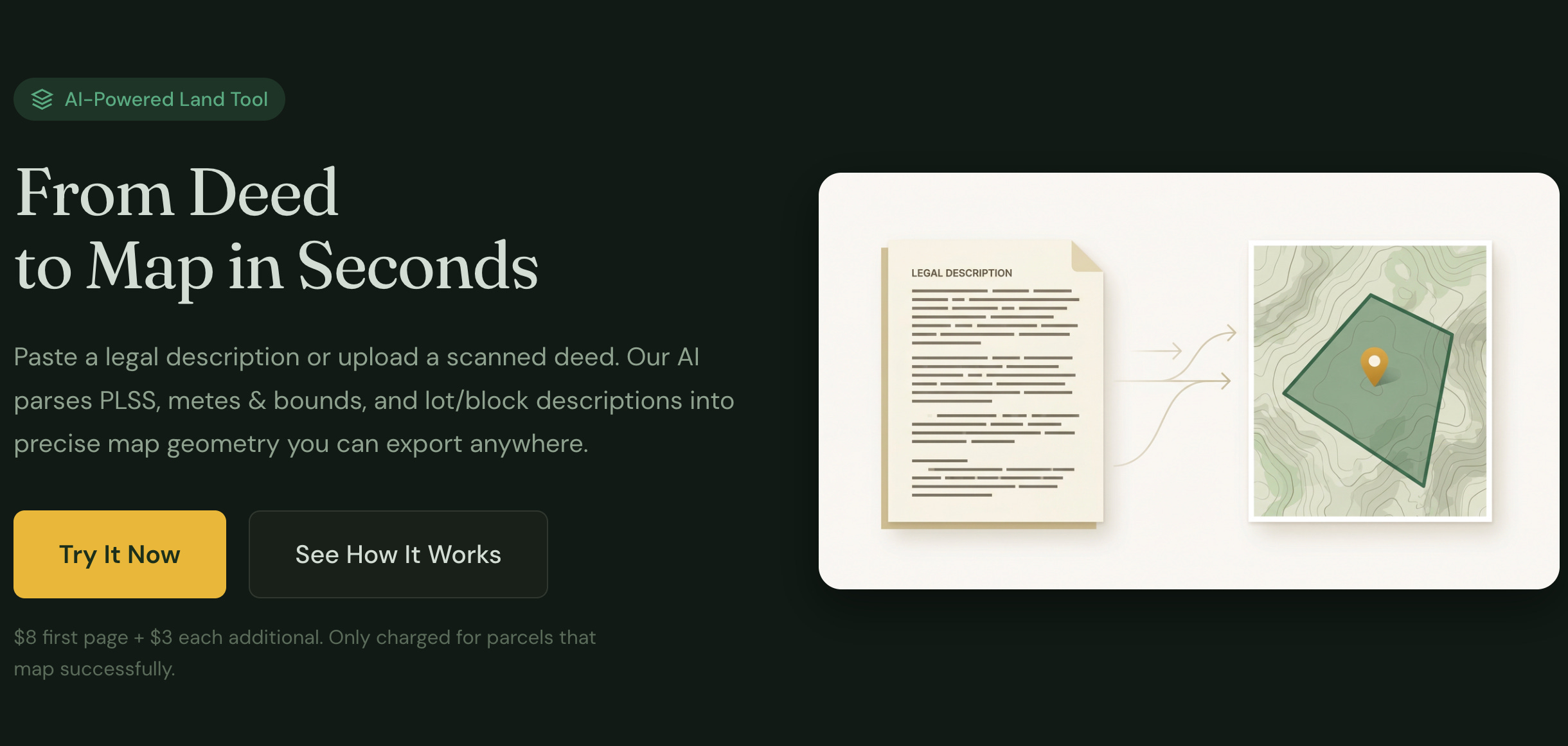
We’ve been quiet on the Farmapper front for a while, but still staying busy building something weird. Today we’re launching tater.farm, a standalone tool that converts legal property descriptions into actual map geometry.
But first, a critical question.
Why Taters?
We get asked this a lot. Well, nobody has asked us this yet because we just launched, but we’re manifesting the FAQ energy.
Here’s the thing: taters and legal descriptions have a lot in common.
A tater is good one at a time. You don’t need a subscription to a potato. You don’t walk into a restaurant and say “I’d like to sign up for the $79/month Russet Plan with annual billing.” No. You want a potato, you get a potato, you eat the potato. Transaction complete. Everyone’s happy. That’s how we feel about mapping legal descriptions. You’ve got a deed. You want to see it on a map. You shouldn’t need to call your accounts payable department and get a software procurement approved for that.
Taters have utility, they are bland and allow a multitude of garnishments. You can mash them up. You can take multiple taters and combine them into something greater than the sum of their parts. That’s literally what our tool does with multi-parcel documents. Except instead of butter and garlic, we use AI and BLM cadastral data. Both are delicious in their own way.
Each tater is the soup hero. Every good soup has one. It doesn’t need to be the whole meal. It doesn’t need to take over your kitchen. It shows up, does its job, makes everything around it better, and doesn’t ask you to sign a 12-month contract for the privilege.

That’s tater.farm. It’s the soup hero of your GIS workflow. Before you say you don’t want GIS in your soup, wait a second as everyone wants something simple. Or at least something that is complicated, made simple. Tater.farm turns legal descriptions into map geometry. Use it, export your data, take it wherever you want. Farmapper, QGIS, ArcGIS, Google Earth, a napkin — we don’t care. Your data, your choice.
Why the cheap pricing, well the domain was $8. We are not above being influenced by cheap domain names and wanted to keep taters cheap enough for the soup.
Simple Tools for Complicated Land
Here’s a confession: Farmapper is complicated. It’s a full platform — fields, crop data, equipment tracking, layers, integrations, the whole operation. And that’s great if you need it. But sometimes you don’t need the whole kitchen. Sometimes you just need a potato.
We kept running into this ourselves. Someone would ask “hey can you show me what this legal description looks like on a map?” and the answer was “sure, let me log into Farmapper, create a project, set up the layers, configure the—” and by that point everyone’s eyes have glazed over and the meeting moved on.
tater.farm is the opposite philosophy: simple tools that do one thing well and feed into whatever platform you’re already using. No lock-in. No proprietary format. No “well you could export that data but you’d need the Enterprise tier.” You get KML, GeoJSON, or Shapefile. Standard formats. Take them anywhere.
Think of it like Unix philosophy but for land tools. Small, sharp, composable. Except one of them is shaped like a potato and has a cape.
OK But What Does It Actually Do
Right. The tool. You have a legal description that reads like:
The NW1/4 of the SE1/4 of Section 15, T3N, R2E, Boise Meridian, EXCEPT the northernmost 55 feet.
And you want to know what that actually looks like on the ground. Currently your options are:
Expensive desktop software you installed in 2014 and pray still works
A $30-100/month subscription you feel guilty about because you use it twice a year
Squinting at a plat book and going “yeah, that’s probably about right”
Calling the surveyor and waiting 3 months
tater.farm adds option 5: Paste it in, get a map, pay a few bucks. That’s it. No account creation. No free trial that turns into a surprise charge. No salesperson named Kyle emailing you for a “quick 15-minute demo.”
How it works:
Upload a scanned deed (JPEG, PNG, PDF, TIFF) or paste the legal description as text
The AI reads the whole document first — figures out how many parcels there are, what types of descriptions you’re dealing with, any exceptions or carve-outs
Then it parses each parcel individually — PLSS references get resolved against real BLM section geometry, metes & bounds get full geodesic traverse calculations
Your parcels appear on a satellite map where you can click around, zoom in, and verify everything looks right
Export as KML (Google Earth), GeoJSON (QGIS, ArcGIS, anything), or Shapefile (.shp) for the GIS traditionalists who respect a classic format
What It Handles
PLSS descriptions — quarter-quarter sections, lots, government lots
Metes & bounds — full traverse with bearings and distances, click-to-set Point of Beginning
Dimensional exceptions — “EXCEPT the North 200 feet” and similar carve-outs
Highway/road exceptions — visually distinguished on the map
Multi-parcel documents — that 9-page deed with 6 parcels and 3 exceptions? Send it through
Scanned documents — AI-powered vision handles rough scans, faxed copies, that one deed from 1974 that’s been photocopied so many times it has its own personality
Screenshots of each parcel or tract.
The Pricing (It’s Simple, We Promise)
$3 for the first successful parcel. $1 for each additional call, such as more parcels, exceptions, etc.
Your card gets authorized when you submit, but you only get charged for parcels that successfully map. If the AI can’t parse something, you don’t pay for it. If your 5-page document has 3 parcels that work and 2 that don’t, you only pay for what worked. Just like that bag of spuds you have in the cellar. You can sort out the green, and sprouted and keep what works for you.
Compare that to the subscription landscape. If you’re a title company processing 50 descriptions a day, those subscriptions make sense. If you’re a farmer, investor, real estate attorney who needs this a few times a week, you were previously subsidizing everyone else’s usage. Not anymore.
Per-document pricing. Like a potato. One at a time. Or two, nobody is looking.
It’s Early (But It Works)
This is a launch, not a finished product. The core engine handles standard PLSS and metes & bounds descriptions well, and we’re improving it constantly. Some things on the radar:
Lot/block (platted subdivision) descriptions — coming soon
Bulk processing / API access — if there’s demand
More edge cases — your weird legal descriptions make the tool better
Try Breaking It
Seriously. Go to tater.farm and throw your messiest legal description at it. The ones with 4 exceptions and a metes & bounds that references “the old oak tree on the Johnson property line.” We want those. That’s how the tool gets better. Though for the oak tree you would need to know where the landmark is and mark it.
If it works, great — you just got a map polygon for $8. If it doesn’t, you don’t pay, and we learn what to fix.
Either way: better than squinting at a plat book.
Subscribe for updates on new features, formats, and the occasional potato metaphor. We also have an email signup on the site if Substack isn’t your thing.