Around the World with Farmapper and Google Earth
Using KML export and import to round trip from Google Earth to Farmapper
Originally published on medium 12/13/2019 but updated for improvements made to the Farmapper protocol.
In this post, I’ll share a framework for how to work with Google Earth and Farmapper to extract KML shapes from a Google Earth file and import into your Farmapper project and to also export the file to KML to be able to view and use on Google Earth.
First Google Earth is fantastic tool made by Google and not affiliated with Farmapper in anyway. The building block of Google Earth is a KML file. What is a KML? The Keyhole Markup Language, or KML, allows users to create customized layers shapes, placemarks and pins to show their data on the Google Earth representation of the 3rd rock from the sun. For simple purposes, a file with the .kml extension can be opened in Google Earth and it will fly you to the location to get the bird’s eye view of the shape or pin in the program.
For this project you will need both the Google Earth program, downloadable at https://www.google.com/earth/ depending on whether you want the desktop, mobile or browser version. For this project we use the Desktop version as it supports KML import. You will also need a free tier, Farmapper account available at https://www.farmapper.com/start_app
Mission 1: Create a Farmapper project to export to Google Earth
For this project you can create your own project or follow the tutorial to make the sample project.
First, go to https://www.farmapper.com/start_app and login to make save the project in the cloud so that you can come back to it. We will create a project for a farm that we see for auction to be able to research it and perform due diligence.
The legal is:
SE1/4 of Section 30, Township 9 South, Range 42 West of the 6th PM, DESCRIPTION: Kit Carson County, CO.
In the Farmapper app, we click on the Input Tab to bring up the ability to search and map by legal description. For more on legal descriptions
Enter the State “CO”
Meridian “6th PM”
Township “9 South” and Range “42 W”
The program drills down the database. Next plug in Section “30”
Last we want the SE quarter. Remember from our legal description post that we start from the inside and work out.
Should look like the Image
Last Click “Save” and voila your target is mapped as a tract
This is only a projection and is not a substitute for a legal survey, so check for reasonableness, etc. In this particular example, the projection is wonky. part of the difficulty of projecting a flat grid on an ellipsoid object. This doesn’t look like a correction section, but it is clear that the grid takes a jog. See image.
So we delete and draw the image using the polygon drawing tools to match what we think it should look like and the maps provided by the auctioneer.
Add stickers from our customized set and customize the names these will be exported into Google Earth as placemarks.
:earth_americas:
There are export options with the </> button, including export KML. This will save the KML file (with stickers) in your documents.
Download the KML file and click on it and it should open in Google Earth for Desktop (you need to have downloaded Google Earth desktop). There it is in Google Earth with the fancy Farmapper stickers as a placemark
We have published this Farmapper project using the following public link for you to check out and skip ahead if you choose:
Mission 2: Use Google Earth to Export KML and Import Project into Farmapper
For this mission we will do basically the opposite. Sometimes we already have a KML file or a project in Google Earth, but we want to import it to customize with stickers, start a Farmapper Channel listing, research USDA Cropscape, etc.
The auctioneer had already provided a useful KMZ file which is basically like a zipped up project that includes KML files for an auction near Joseph, Oregon
We open in Google Earth and have the Screen Above with the Joseph Ranch KMZ file. We click on the KMZ to reveal the detail below it and drill down.
He highlight and Click on “Save Place As”
Make Sure and Save File as “.kml” not as a “.kmz” file
Now you should have successfully extracted the .kml file and it should live on your desktop.
We go to Farmapper Application and Start a new project named Joseph Ranch
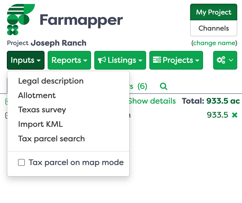
Go to Inputs Tab and Select “Import KML”
Find the File on your Desktop and Select it to begin the Farmapper processing of the KML file into your project.
When it is done you will have the following
Bonus Time with Customization
Let’s dress up the tract shape and lay out some markers using Farmapper custom stickers
Add sticker icons to beautify and describe the parcel in more detail as below. We add some stickers to mark the improvements, the pasture and feedlot and even the fishing spot.
We also sprinkle in additional data to each sticker, for example add 111 acres to the Pasture sticker. Click on the sticker and add additional data.
We Export to KML again. And voila our Farmapper map is in Google Earth, with fancy sticker as placemarks.
The additional data comes in to the image as well. See the data about acres is now appended to the Google Earth placemark.
We publish this project to the public URL as well so you can see the project and access the KML files if interested. https://www.farmapper.com/project/public/ahNzfnNwcmluZy1iYW5uZXItODM5ch0LEhBQcm9qZWN0UHVibGljVXJsGICAgKydiZAKDA
The objective of farmapper.com in simple terms is to bring agriculture together on the map. Please give us a clap or two and let us know what we should write the next series on.
Follow us on Twitter: @farmapper
Visit our Website: www.farmapper.com
Checkout our Facebook: https://www.facebook.com/farmapper/


